

|
|
|
|
|
|

|
METAR s - TAF s Cyprus
|
|
|
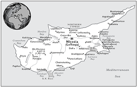
Location: Middle East, island in the Mediterranean Sea, south of Turkey.
Geographic coordinates: 35 00 N, 33 00 E
Terrain: central plain with mountains to north and south; scattered but significant plains along southern coast.
Lowest point: Mediterranean Sea 0 m.
Highest point: Mount Olympus 1,951 m.
Climate: temperate; Mediterranean with hot, dry summers and cool winters. |
|
|||
| THE USER ACCEPTS SOLE RESPONSIBILITY AND ALL RISKS ASSOCIATED WITH USE OF THE METARs TAFs INFORMATION ON WWW.KIFISSIAMETEO.GR WEB SITE | |||
|
|
||||||||||||
|
|
|
||||||||||
|
| ||||||||||||
|
Web site Design and Development by: Giannis P. Fragos |
||||||||||||
|
|
||||||||||||